One of my current favorites is Finewoodworking.com's Digital Furniture Project Plans. Anatole Burkin, VP Digital Content Director of Taunton Press, noted that this will appeal to anyone who's interested in modifying one of the projects listed on the website. Being able to adapt a design to suit your sensibilities is useful to both the people who buy the plans and those who offer them for sale. Most plans are only $12.95 and include printable PDFs.
Woodworkers <3 SketchUp
Tuesday, March 31, 2009
One of my current favorites is Finewoodworking.com's Digital Furniture Project Plans. Anatole Burkin, VP Digital Content Director of Taunton Press, noted that this will appeal to anyone who's interested in modifying one of the projects listed on the website. Being able to adapt a design to suit your sensibilities is useful to both the people who buy the plans and those who offer them for sale. Most plans are only $12.95 and include printable PDFs.
3D Warehouse models available in COLLADA file format
As a result, we've changed things so that soon after upload, we generate the COLLADA/Google Earth file on the server using the provided SketchUp file. What does this mean? First, you'll find more models that do load properly when you follow the "View on a 3D map" link. Next, every model in the 3D Warehouse will now be available in the COLLADA format. Finally, you'll find that the COLLADA and Google Earth files are more compatible with Google Earth, the Google Earth plugin, and other 3D applications that are COLLADA-compatible (like Photoshop). You'll have to wait until our systems can convert your SketchUp file before you'll find the Google Earth and COLLADA files available for download, but this process shouldn't take more than a few hours. Please let us know if there are questions or comments about this change.
Posted by Mark Limber, 3D Warehouse Product Manager
More 3D buildings in Google Earth
Monday, March 30, 2009
This release was significantly larger than previous releases. Thousands of user-generated models were pushed live and we hope yours was included! The reason for the increase is that we've been working hard to identify and review 3D building models that may have been overlooked. Many thanks to our loyal modelers who have helped to identify these deserving models, and been patient while we work out some kinks in the process.
If you're a geo-modeler and have been waiting for your model to be reviewed, have a look to see if it made it in this release. If not, then stay-tuned. We've already started the process of re-reviewing each and every "Google Earth ready" model submitted to the Google 3D Warehouse. It's no small undertaking but we're committed to having this completed very soon.
In the meantime, hats-off to the many modelers whose models were included. To highlight a couple....check out the Chrysler building in New York modeled by Kevin Girard, or Saint Peter's Basilica and Square in Vatican City by Antonino Grasso Cristaudo. Awesome work guys!
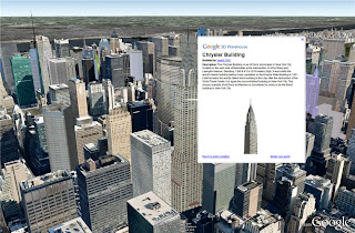
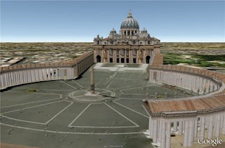
Posted by Bruce Polderman, Sr. Business Product Manager
SketchUp is now available in Chinese (Simplified)
Thursday, March 26, 2009
Posted by John Bacus, SketchUp Product Manager
SketchUp 7 For Dummies book
Tuesday, March 17, 2009

Our friends over at Wiley Publishing have just released the popular Google SketchUp For Dummies book in a new edition that covers SketchUp 7 - both free and Pro! You can find the book online and at brick-and-mortar booksellers. The new edition is fully updated and includes:
- a brand new section on the Sandbox tools
- a brand new section on modeling organic shapes with the Scale, Push/Pull, and Follow Me tools
- a brand new section on Dynamic Components, including how to use them and how to create them
- coverage of the new photomodeling tools
- a revised chapter on LayOut 2
Help model the world – one bridge at a time
Monday, March 16, 2009
Simply model your bridge in Google SketchUp, geo-reference it in Google Earth, and submit the bridge by uploading to the Google 3D Warehouse to earn eternal online glory and, if you win, a handsome prize. You can enter this competition if you're a student at a higher education institution almost anywhere in the world. Take a look at this 3D Warehouse collection to get inspired, and good luck!
Posted by Allyson McDuffie, SketchUp for Education Program Manager
Ecce Triumphatores!
Sunday, March 15, 2009
Our panel of educational thought leaders included Bernard Frischer, Director of the Institute for Advanced Technology in the Humanities, University of Virginia, Roberta Johnson, Executive Director of the National Earth Science Teachers Association, and Michael H. Levine, Executive Director of the Joan Ganz Cooney Center at Sesame Workshop. They chose to recognize the following teachers for their excellent lessons -- and all these lessons can be found on the Google for Educators website for other teachers to adapt them for their own classrooms:
Grades 9-12
- Benjamin Johnson of Hampden Academy in Hampden, Maine for his lesson, Walking in the Footsteps of the Romans (he even created a great video of his lesson, available on YouTube).
- Amy Rechtiene of Lake Norman High School in Mooresville, North Carolina for her lesson, A tour of Rome Fit for an Emperor
- Sarah Ellery of Montgomery Bell Academy in Nashville, Tennessee for her lesson, Walking with the Emperors
- Cheryl Davis of Acalanes Union High School District in Lafayette, California for her lesson, Roman Holiday with the Ancients
- Jennifer Wagner of Calvary School in Wildomar, California and Kathy Shields of Creek View Elementary in Alpharetta, Georgia for their lesson, Archy-the-Arch
- Ingrid Gustafson and Carol Alcusky of Sarah Gibbons Middle School in Westborough, Massachusetts for their lesson, The Roman Record
- Ivan Nieves and Sally Hatcher of Winsor School in Boston, Massachusetts for their lesson, Ecce Rome
- Mijana Lockard and Craig Hilgenberg of Lincoln Avenue Academy in Lakeland, FL for their lesson, What can we Learn from Ancient Societies?
Posted by Anna Bishop, Google Earth Education Team
Design competition announced by Dwell
Their spring competition seeks to improve the design of everyday objects (towel racks, toothbrushes, transit vehicles) and is split into two phases. In phase one, you submit your suggestions for everyday objects that need re-imagining and then the Dwell editors will choose the three best ideas from all entries. Enter the first phase by March 31st. In phase two, you will submit a design proposal for one or all three most tragically-designed objects from phase one. They're inviting products designed using Google SketchUp. You can also use LayOut to put together your proposal. Enter your ideas today.
Posted by Tasha Danko, SketchUp Product Marketing
Live from Mars!
Friday, March 13, 2009
Just last month, we released Mars in Google Earth 5.0 and finally satisfied the long-standing demands of our Martian userbase. However, much to our delight, Mars has also proven popular among Earthlings, so today we're pleased to announce several new features for Mars in Google Earth designed specifically for our human users. Together they highlight humanity's newest and oldest views of the red planet: Live from Mars, Historical Maps, and Guided Tours.
 | Live from Mars: NASA's typical release process for Mars satellite imagery requires months, and involves numerous stages of calibration. But thanks to the THEMIS camera team at Arizona State University, you could turn on the new 'Live from Mars' layer and become one of the very first people to lay eyes on images taken just days or even hours ago! This feature represents the first public continuous stream of fresh high-resolution satellite imagery in the solar system, and can display new images from the THEMIS camera just hours after NASA receives them. You can also see live satellite orbital tracks, or check out where the HiRISE camera plans to image next. |
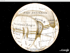 | Historical Maps: In the late 1800s, Giovanni Schiaparelli created many of the earliest detailed maps of Mars. He famously saw, recorded, and named numerous linear features on the surface, some of which he termed cannali (Italian for channel). His contemporary, Percival Lowell, re-imagined and misunderstood these features to be artificial canals, sparking a media frenzy back on Earth and captivating the public with the idea of abundant water and an alien civilization on Mars. The Historical Globes layer lets you see these and other antique maps of Mars as virtual spinning globes. |
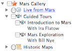 | Guided Tours: If you're not sure where to go on Mars, let Bill Nye the Science Guy and Ira Flatow of Public Radio's Science Friday show you around. Simply go to the Mars Gallery layer, and double-click either of their tours for a narrated trip around the Martian surface. This is a great way to introduce yourself to some of the most interesting spots on the planet - just sit back, and enjoy the ride. If something catches your eye, you can pause these tours at any time and explore on your own, then hit play to resume your journey. These tours were created with the new Touring feature in Google Earth 5.0. |
Mars in Google Earth also contains several other layers with useful information about the Red Planet. There's a browsable layer of our favorite satellite images, visible and infrared global views, geo-located excerpts from A Traveler's Guide to Mars, and others. We've also included 3D models of NASA rovers and, if you follow their tracks, the 360-degree panoramic photos they captured from the surface. Just like browsing on Earth, you can use the search box to locate famous sites like the face on Mars. Who knows, you might just find a new Martian friend to chat with...
To enter Mars in Google Earth, click the planets button in the main toolbar and select 'Mars':

We hope you enjoy these latest additions. They're made possible by Google's Space Act Agreement with NASA, which enabled NASA Ames researchers to develop much of this content. You can visit earth.google.com/mars to learn more about Mars in Google Earth.
Posted by Michael Weiss-Malik, Martian Product Manager
Announcing the OpenStudio Plugin
Wednesday, March 11, 2009
Also, keep an eye out for a joint SketchUp and EnergyPlus training session at this year's AIA Conference (American Institute of Architects) in San Francisco. If you're a developer and would like to contribute to this open source project, please visit the OpenStudio SourceForge website.

Posted by Chris Cronin, SketchUp Sales Team
Cool technologies to help visualize your models
1) The first cool integration comes from Inglobe Technologies. Born from individuals in the Scientific Research and Design communities, their technology revolves around the creation of "Augmented Reality". What the heck is "Augmented Reality"? In short, it is the concept of combining reality with virtual reality.
Their new "ARplugin" for SketchUp will combine what you see through a standard computer video camera (reality) with your SketchUp model (virtual reality). With a simple click of their ARplugin tool and your model will export into the world of AR and you will be able to handle the model as if it is in you hand!
Just as we at Google SketchUp have preached "3D for Everyone", I was told that Inglobe too are evangelizing AR for anyone. So give it a try. They have a free download so you can try it out.
Sorry Mac lovers, but currently the ARplugin is Windows only but I have been informed that a Mac version is in the works.

Be sure to check out some of Inglobe's augmented reality videos on YouTube as well as others pertaining to the world of Augmented Reality.
2) The second cool integration is from a company called Deliverance Software out of the UK. Evolving from a terrain editing application for game developers and their work with the Department of Landscape at the University of Sheffield, their product line allows you to insert your SketchUp model into a game like environment for you to do real-time walk throughs, fly overs and animations with your SketchUp designs. And if you have those 3D glasses, you can even set it for stereo view to get the 3D effect you see in 3D Movies.
The WalkAbout3D is their most basic product and it will allow you to load your SketchUp model into the engine directly while in SketchUp. Their enhanced product is called Symmetry3D and it will allow you to work with 3D terrain, load multiple 3D models, and create animations/simulations. They have posted multiple videos on YouTube showing both applications in action.
New 3D Cities in Google Earth
Friday, March 6, 2009
Posted by Bruce Polderman, Sr. Business Product Manager
A shiny new Ruby API site
 We would also like to take this opportunity to mention that the Google I/O Developer Conference is May 28th and 27th in San Francisco, CA. Members of the SketchUp team will be presenting in the What you don't know about Geo APIs can't hurt you session and will also be available during Office Hours. Hope to see you there!
Posted by Bryce Stout, Product Manager
Introducing SketchUp Sages
Wednesday, March 4, 2009

There's a brand-new source of SketchUp salvation on the Interweb, and it's a doozy. SketchUp Sages is a collection of the very best advice from some of the very best SketchUp modelers on the planet. These kind, expert souls have put together a one-stop place to look for all kinds of answers and it's great.
The site starts with a section that answers the question, "How do I make SketchUp run faster?" ...and it only gets better from there. If you consider yourself a SketchUp enthusiast, you owe it to yourself to visit this site ASAP.
Posted by Aidan Chopra, SketchUp Evangelist
Community modeling in Madison, NJ
Monday, March 2, 2009
It all started with Mayor Mary-Anna Holden attending the National Main Street Conference last year. This conference is attended by community leaders from around the country who want to learn about creative ways to promote their downtowns. Google attended the event and presented how McMinnville, Tennessee had used Google SketchUp to model their downtown.
Attendees, including Mayor Holden, saw the potential that such a model could have on their town and kept asking “How do we do this?".
In Mayor Holden’s case, the answer rested with the son of her neighbor, a young man by the name of Teddy Bogdanski. Mayor Holden approached Teddy, a Boy Scout, with an idea for an Eagle Scout project, which lead an effort to model Madison.
Soon after they spoke, I received an email from Teddy asking if Google would be willing to support the effort. How could I decline an Eagle Scout? I replied that we would. A date was established where my colleagues and I would travel to Madison and conduct a short training effort on the use of SketchUp to model for Google Earth.
With Googlers agreeing to visit his town, Teddy had work to do to ensure that his project was a success. His role was that of a coordinator & project manager, and he did a stupendous job.

We’d conducted product training before, but not an abbreviated one with a focus on creating textured models for Google Earth. While we did this, Teddy was hard at work collecting volunteers and approval to use his high school computer lab. I’m not sure who had the tougher job: Teddy or us... but I’m pretty sure it was Teddy.
When we walked into Madison High School early Saturday morning we were greeted by Teddy, his parents, teachers, and 25 volunteers eager to help. It was awesome. We got right to work.
Aidan Chopra, the author of SketchUp for Dummies, kicked the day off with a short lesson on the basics of SketchUp. Craig D’Andrea from our team followed with a demonstration and instruction on how to apply digital photos to 3D SketchUp models. Within an hour the mice were flying, the keyboards were clicking, and hands were being raised. The three of us spent the remainder of the day providing support to the group.
Models of downtown began to take shape, and within a few hours a number of models were already completed. Smiles were crossing the faces of those finishing models as they pointed at their screens with pride. Madison was quickly becoming a virtual city.
Teddy and his group of volunteers have scheduled two subsequent meetings to complete their downtown. We look forward to seeing their models in Google Earth very soon, and wish them the best in their efforts.
We would like to encourage other towns to follow the lead of these pioneers. If you have questions about how to proceed, please visit the Cities in 3D Program.
Posted by Bruce Polderman, Sr. Business Product Manager
SketchUp in more of your languages
Sunday, March 1, 2009
Posted by John Bacus, Product Manager