DoubleCAD XT and SketchUp

Tuesday, December 28, 2010

Having been here for almost seven years, I've concluded that there are as many SketchUp workflows as there are SketchUp users. Trying to recommend a single catch-all combination of tools and methods is like stapling Jell-O to a piece of paper — difficult, messy and ill-advised. When tools like DoubleCAD XT (and DoubleCAD XT Pro) from IMSI/Design come along, things get a little easier to explain.

Most SketchUp modelers who design things for a living spend their time somewhere between the second and third dimensions. Models are 3D, but construction (or fabrication) requires 2D documents. Often, those 2D drawings are too complex to use LayOut in SketchUp Pro to make; LayOut isn't a dedicated drafting tool, after all.

A SketchUp model imported into DoubleCAD XT Pro

DoubleCAD XT is (as its name implies) most certainly a full-featured CAD tool. It's more affordable than AutoCAD LT, and it "holds hands" with SketchUp better than any other CAD system on the market. Among other things, DoubleCAD XT:

  • exports COLLADA files which you can open in SketchUp
  • imports .SKP files natively
  • imports and recognizes SketchUp layers
  • generates viewports from scenes in your models
  • converts components into DoubleCAD blocks automatically

If you're a Windows user who routinely creates 2D documents, you owe it to yourself to give DoubleCAD a whirl. The no-cost version (did I forget to mention that DoubleCAD XT is free?) is extremely capable, and the Pro version adds lots, lots more for US$695.

Dashing through the snow... with NORAD and Google

Thursday, December 23, 2010

[Cross-posted from the Official Google Blog]
Every Christmas Eve, children all over the world ask themselves—and their parents—questions about Santa’s magical journey: How does Santa visit so many children in one night? Will he eat the cookies I left out? How does he fit all those presents into his sleigh? These childhood mysteries are part of what makes the Santa tradition so special. There’s one timeless question that we’re proud to say we can help answer: Where in the world is Santa at this very moment?

Thanks in part to recent advances in warp-speed GPS technology and some very clever elves (elveneering?) NORAD Tracks Santa is once again prepped and ready to go.

Starting tomorrow, December 24 at 2:00am EST, visit www.noradsanta.org to follow Santa as he journeys around the world delivering presents to children in more than 200 countries and territories. There are a few different ways to find the jolly old man in his unmistakable red suit over the course of the day, so feel free to track him using any of the following methods:

  • See Santa on a Google Map: On your home computer or laptop, visit www.noradsanta.org and choose your preferred language. You’ll see a large Google Map on the page displaying Santa’s current location and his next stop. Click the video icons to watch “Santa Cam” videos, and click the gift icons to learn more about each city.

  • Watch Santa fly with the Google Earth Plug-in: From www.noradsanta.org, click on the link Track Santa in Google Earth. You'll see Santa steering his sleigh right on the webpage. If you don't have the Google Earth plug-in, you can get ready by downloading it ahead of time.

  • Follow Santa on your phone: Track Santa from your mobile phone by opening Google Maps for mobile and searching for [santa]. Or, visit m.noradsanta.org on your phone’s browser.

  • Subscribe to his YouTube channel: Santa’s home on YouTube is at http://www.youtube.com/noradtrackssanta. That’s where you can find videos from his journey throughout the night.

  • Get real-time information about Santa’s location: Use Google’s Realtime Search to get updates from social networks, news and micro-blogs like Twitter at @noradsanta, and keep up with news about his journey on this Facebook page.

For any techie questions you might have, we’ve also put together some helpful tips and tricks about all the cool ways you can experience Santa’s journey. Now that you know how to follow Saint Nick on Christmas Eve, it’s our tradition to tell the story of how this all started...

NORAD (North American Aerospace Defence Command) first began to track Santa in 1955 when a misprinted advertisement in a Sears & Roebuck catalogue mistakenly led callers expecting a Santa-hotline to the NORAD commander-in-chief's telephone. Embracing the spirit of the season, NORAD used its satellite and radar capabilities to offer callers sleigh-location updates, and has tracked Santa's whereabouts on Christmas Eve ever since. Then in 2004, Google started tracking Santa on Google Earth as a 20% project, which in 2007 grew into a partnership with NORAD, adding the mapping technology of Google Maps and Google Earth to the NORAD experience. Over the years, other Google teams have also joined in the holiday fun (YouTube, Google Voice’s www.SendACallFromSanta.com and Google SketchUp).

As we approach this year’s Christmas Eve adventure, Santa was able to take a break from the preparations to visit the New York Stock Exchange this past Monday. His helpful elves kept everything at the North Pole on schedule while folks from Google and NORAD attended the Closing Bell ceremony, and stood alongside Santa from Macy’s going over last minute details about tomorrow’s big ride.

Santa with NORAD, Google and members of the Marine Toys for Tots Foundation (that’s me, the tall guy in the back row clapping)

So don’t forget to visit www.noradsanta.org tomorrow morning starting at 2:00am EST when Santa embarks on his flight. From all of us here at Google, happy holidays and here’s to a very happy New Year!


Announcing the Google SketchUp + Ponoko Challenge Winner

Wednesday, December 22, 2010

The winner of the Google SketchUp + Ponoko Challenge is in. Congratulations to Ed Lewis, aka Fungus Amungus, who created a wonderful instructable about using SketchUp with Ponoko 3D printing!

In his instructable, Ed walks through 7 easy steps to go from a simple cube in SketchUp to a 3D printed, level-3 Menger sponge.

Menger sponge in SketchUp and printed with Ponoko’s durable plastic.

Ed has won a SketchUp Pro license, a 12-month subscription to Ponoko Prime and a $537 Ponoko digital making voucher.

Upon winning, Ed told us, “it’s great to see more and more tools of creation, like Ponoko, being opened up to everyone.” We couldn’t agree more.

Congrats to Ed for winning the grand prize and congrats to Ponoko for making a great 3D printing tool!

Holiday trees in 3D

Tuesday, December 21, 2010

(Cross-posted from the Google Latlong blog)

Can you imagine the holidays without fir, spruce and cedar trees decorated with colorful ornaments? Beyond tracking Santa, we’re getting into the spirit of the season by placing 3D holiday trees in more than a dozen places on Google Earth 6.


Check out the Rockefeller Center in New York City. The only thing that would help make this scene even more festive would be crowds of people bearing shopping bags and a light dusting of winter snow! And don’t you just love how the ornaments on the New Year Tree in Moscow’s Red Square reflects the vibrant colors of Saint Basil's Cathedral?


Rockefeller Center


Red Square

One of the most interesting places where we’ve added holiday trees is Austin, Texas, along highway 360 near 2222. Every year when the holiday season starts, the cedar trees along this section of highway called Loop 360 are mysteriously dressed up in tinsel, ornaments and lights. Some say elves are responsible for spreading this holiday cheer, and we’re excited to celebrate and tribute the fun local activity with digital replicas of the trees!


In all, there are fourteen places where you can find holiday trees in Google Earth 6. Can you find them all?


Posted by Kay Chen, 3D Data Specialist

And the newest Supermodeler is... Tang

Last month, we introduced a new process for awarding Supermodeler status to the world's best geo-modelers — fewer than 70 men and women can claim this designation. As the winner of the November vote, Huang Chung-Tang (a.k.a. Tang) is the most recent member to join their ranks. With 140 top-notch models currently in Google Earth’s 3D Buildings layer, he’s certainly deserving of the honor. We interviewed Tang after we informed him that he’d come out on top.


Tiananmen Square

Why do you geo-model, and when did you start?

I specialize in Interior and Space design. When I was young it was my dream to become an architect, so I wasn't able to fulfill my dreams. With SketchUp I was able to see that dream come true, and because of that, I started building geo-models for Google Earth. It’s a passion that I will continue in the foreseeable future.


Office of the President, Taiwan

My first model passed through Google’s review process and appeared in Google Earth’s 3D Buildings layer in 2008. The feeling of excitement when I see my models in Google Earth remains today. Maybe this is the Google Earth and SketchUp charm. I think all modelers share this kind of feeling.


EXPO 2010 Shanghai China | China Pavillion 201007

Do you have specific modeling goals?

Yes. It’s my hope that more people in Taiwan will participate in geo-modeling. We could create a community where we work collaboratively to build geo-models of Taiwan to appear on Google Earth.


Taichung Central Science Park West District Water Tower

What model are you most proud of?

I have many models that I am proud of, such as: Tiananmen Square, the Forbidden City in China... etc. but I have to say, i'm most proud of the Taipei 101, because it represents a major landmark in Taiwan, and Taipei 101 exterior contains a deep and strong oriental meaning. That was the whole reason I wanted to take on that project.


Taipei 101

What is your favorite model created by someone else?

That’s a tough question to answer because I admire many modelers including Enrico Dalbosco, José Manuel, Zeljko Zdravkovic, Filip Michalowski, Tomasz Szular, TANTUNNY, and others. If I had to choose, I’d have to say that my favorite modeler is Peter Gipuzkoa. He's working hard to turn Spain into 3D, and it is because of him, 3 years ago, that I set out to do the same for Taiwan.


Arrow Building Zhengyangmen

My goal is have more buildings of Taiwan to be seen by everyone around the world. In the last few years Peter has taught me a lot about modeling, and helped me produce better models using SketchUp. I think this is what they mean by a "global village."

Award-winning lamps come to life

Monday, December 20, 2010

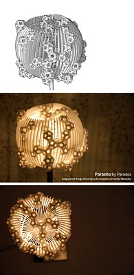
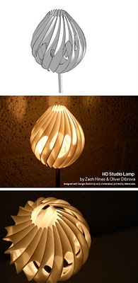
A few weeks have passed since the winners of the 3D Printed Lamp Design Challenge for SketchUp were announced. Our friends over at Materialise have had time to print out the winning designs; we thought you might like to see the amazing results.

First Place:
3D Maze by Corre

Second Place:
Parasite by Paradox

Third Place:
HD Studio Lamp by Zach Hines & Oliver Dibrova

Jury Prize:
Amazelight by Oscar Rottink

Check out the i.materialise blog for more information. I’m totally going to print myself a chandelier for Christmas.

Beryl Builds Billerica

Friday, December 17, 2010

Beryl Reid has been busy. In August of 2009, Beryl (a.k.a. BerylDrue) traveled to our Boulder, Colorado office to become a Google Certified Teacher. Then in April of this year, she became a Supermodeler. She liked Boulder so much that she even came back to attend 3D Basecamp 2010 this past September. How much more involved with SketchUp could Beryl get? As it turns out, plenty.

Model of the Billerica Train Station

Though she’s a recently-retired computer teacher from Billerica Memorial High School (in Billerica, Massachusetts) Beryl is still actively involved with the school. This year, she was asked to give a SketchUp demo to the school’s new Introduction to Engineering class. The presentation was such a success that she was asked to return to teach the students more advanced modeling techniques that would ultimately help them geo-model their hometown.

We asked Beryl why she had decided to teach this geo-modeling workshop: “To me it was a chance to get Billerica on the 3D map for the benefit of all those kids who live there and love to explore Google Earth.... There is a lot of colonial history and buildings in the town.”

Workshoppin' at BMHS.

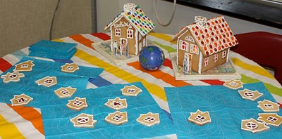
Mmmmm...cookies. And SketchUp gingerbread houses!

Build a model, get a shirt.

Beryl created the Billerica in 3D website to gather all of the workshop information together - the Billerica in 3D collection, building photos, and various resources and “how-to” guides. You can also check out more pictures from the workshop.

New SketchUp 8 book in Portuguese

We know from examining our charts and graphs that the good people of Brazil are crazy about SketchUp. We can officially add 3D modeling to the long, long list of things for which that country is famous.

The first book about Google SketchUp 8 is now available, and it’s in Portuguese. Written by architect João Gaspar, Google SketchUp Pro 8 passo a passo was launched in Sao Paolo on December 3rd, 2010. It’s the author’s third book about SketchUp; he also wrote volumes about SketchUp 6 and 7.

The “City of Love,” now in 3D

Wednesday, December 15, 2010

To foreigners, Paris is the “city of love.” To Parisians, it’s the “city of lights” (La Ville-Lumière). Today, Paris is the “city in 3D.”

Sunrise in Paris

Often considered one of the top destinations for world travelers, Paris is known for landmarks like the Notre Dame Cathedral and the Arc de Triomphe, world-famous museums like the Louvre and the Musée d'Orsay, and hundreds of little bistros with French pastries so good they make your heart pop (literally and figuratively). Now all of these sites – and the many, many others that make Paris special – are available to tour in 3D in Google Earth.


With Google Earth’s “3D Buildings” layer turned on (or by using the Google Earth plug-in for Google Maps) you can wander the streets of the Montmartre district made famous by artists like Picasso, Van Gogh and Dalí from your living room. You can also see the Sacré-Cœur Basilica without having to climb the 237 steps to get there. Instead of waiting in line to see the view from the Eiffel tower, fly straight to the top in Google Earth and get a 360-degree view of Paris. Round out your tour by taking a peek at the Centre Pompidou, which turned the architectural world upside down (or perhaps inside out?) with its exposed skeleton and brightly colored building utilities.

Whether you’re an armchair tourist or planning your next vacation to France, take some time to tour the streets of the French capital and see the historic sites; after all, many of them were created by modelers just like you.

If you’d like to get involved in modeling your town (or any other location), we have several tools to get you started. With Google Building Maker, you can create and contribute a building in as little as 10 minutes. And if you’d like to refine your building, bring it into Google SketchUp for fine-tuning.

Happy touring!

Posted by Gopal Shah, Google SketchUp team

SketchUp Pro Case Study: Daniel Company

This user story comes from Mark Lessmueller at Daniel Company. It came in via the Tell us your story link on the Sketchup Go Green! site.

Daniel Company has switched to Sketchup Pro for the drafting, design, analysis and construction of its air pollution control systems. Sketchup Pro has helped us visualize potential problems in 3D, allowing us to find conflicts on the computer, rather than in the field. This prevents us from wasting material and resources and reduces our carbon footprint. In addition, we can share our drawings and models with anyone across the globe. They can make suggestions directly on the drawings without having to resort to awkward phone conversations about “what change needs to be implemented where”.

This simplicity allows our clients to ensure that there are no intersections with existing equipment onsite during modifications. Additionally, due to the low cost of Sketchup Pro (especially in comparison to similar products), we were able to install Sketchup Pro on virtually all of our engineering computers, rather than just the drafters’ machines. The ability for our engineers to do some of our drafting when the drawings are “bottlenecking” production has proven invaluable.

We are about to begin start-up of the first system we created with SketchUp: a biological system where microorganisms digest the odorous pollutants. The system relies entirely on wastewater treatment plant products to feed the bacteria, rather than the typical method of spraying highly reactive neutralizing chemicals into the polluted airstream. The resultant waste of the bacteria can then be conveyed back into the wastewater treatment plant and treated via the microbes in that system.

SketchUp model details

While the air pollution control system was originally conceived by the treatment plant's design consultant engineer, the actual odor control system manufacture was drafted, designed, analyzed, and constructed using Sketchup and LayOut. This includes an air conveyance system, hydraulic profiles, plumbing layouts, water control panels, two 12' Ø x 40' tall fiberglass reactors, and two 12' Ø x 20' tall fiberglass adsorbers. (Each of the 12' Ø vessels was made in our shop in accordance to the LayOut files.) As the system is starting up, we are also planning to visualize this model in Google Earth.

Water Control Cabinet Concept Model. This model was used to visualize the size of the water control cabinet, as well as feasibility.

Each of the pieces of the ducting (which supplies fresh air to the building and captures the foul air) was modeled in SketchUp and then turned into a cut sheet. Our fiberglass duct, tank, and scrubber shop easily fabricated the individual pieces. Thanks to Sketchup, it is a lot easier to make sure that each piece will fit on a truck (sent from California to Virginia), rather than relying on 2D drafting.

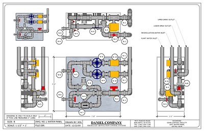
Water Control Cabinet Construction Diagram. Illustrative table to show the flow diagram for the water control cabinet and estimate pressure losses.

Since this was our first major project in SketchUp, most of it was created using the standard SketchUp tools. The plugins we did use were mostly custom modifications of plugins that were available for alteration. The CenterPoint and Conetop plugins were used to help make pipe transitions and to align pipes. We modified the Mesh Additions and the Parametric scripts to create an “elbow tool”. The PVC piping in the water panels was created with a combination of native SketchUp tools, this “elbow tool” plugin and the CenterPoint plugin.

Air Pollution Control Biological Scrubber External Sump - Model Concept Drawing. This illustration shows where rough nozzle placement would occur. The vessel nozzles were rough, and the gussets inaccurate, but this illustration was good enough to ensure that a conceptual model was feasible.


Air Pollution Control Biological Scrubber External Sump - For Construction Drawing. This layout drawing shows the more accurate renderings, the additional nozzles required, and the steps taken to create an FRP vessel for construction.

Since this project, we have created multiple other air pollution control projects using SketchUp and LayOut. We’ve also used quite a few other freeware plugins. (We’re big fans of Fredo6 and Chris Fullmer’s plugins). FredoScale and Joint Push Pull have saved us on a number of more delicate projects, especially where we make a small apparatus and then need to show thickness in the ducting, or building our damper library. And Chris Fullmer's Shape Bender has helped out quite a bit for other jobs where nothing else seems to work.

We’re now working to model some of our older existing projects in SketchUp and visualize them in Google Earth.

Overall component setup. This setup illustrates how each of the vessel components and scrubbing systems connected for a proper system.

Thanks for sharing your work, Mark!


Building Maker: 109 cities and counting

Tuesday, December 14, 2010

Today’s Google Building Maker imagery update is our last one for 2010 – you can now use our purpose-built geo-modeling tool in any of 109 cities around the world. We’ve just released imagery for:
  • Oklahoma City, Oklahoma
  • Oslo, Norway
  • The Hague, The Netherlands
San Antonio, Texas is one of the newest additions to Building Maker.

We also greatly expanded the coverage areas for San Diego, California and Portland, Oregon. And in case you missed the update two weeks ago, we also released imagery for:

  • San Antonio, Texas
  • Tucson, Arizona
  • Norfolk, Virginia
  • Salt Lake City, Utah
Norfolk, Virginia is itchin' to be modeled.

Still waiting for your city to be added to Building Maker? You can request it; in the meantime, try modeling in one of these new cities to help get them on the 3D map.

Meet the SketchUp Sages: Gaieus

Friday, December 10, 2010

If you’ve ever stopped by the SketchUp forums to ask a question, chances are you got an answer from one of the “SketchUp Sages”. Today, we are kicking off a blog post series profiling these SketchUp ninjas. In this inaugural installment, we’re excited to introduce a Hungarian sage by the name of Csaba Pozsarko, though you’ll see him in the forums as “Gaieus”. Like any frequent contributor to the forums, Gaieus had a lot to say, and as as a preeminent sage, his words are wise. Be sure to stop by and visit him in the community if you’d like to learn more.

Gaieus visited the Boulder team from Hungary this year for the 2010 3D Basecamp.

What do you do for a living?

I am an archaeologist by trade, but I now try to model archaeological reconstructions (also) for a living – at least as much as possible. Of course, I do other modeling jobs as well. One does not reject paid jobs on the ground that they are not at least 300 years old.

Then there is SketchUcation where – beside the forums or The Daily CatchUp – we are working hard to launch some new and exciting stuff. However, if I told more now, I am sure my friend, and general director, Mike Lucey would kick me in the rear. Stay tuned...
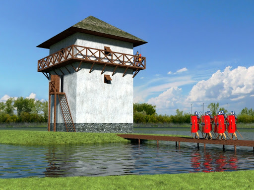
Roman watchtower on the Pannonian limes

How long have you been using SketchUp? / What’s the first version you used?

I started using SketchUp shortly after version 5 was made free by Google...some time around mid-2006. I hadn’t heard about it previously, although I had already been involved in 3D visualization of archaeological sites half a decade before. I worked with five other European partners on the “Peregrinus Project” that we made of Ancient Roman archaeological sites (three of them part of the World Heritage).

One day, I was browsing on Google Earth and happened on a 3D building somewhere I can no longer remember. They were rare back then, and in the Google Earth bubble, there was a link to SketchUp. When I discovered there was a free version to start with, I was sold and never looked back.

I most probably would not have plunged into it if there hadn't been the free version. In my opinion, the 8 hours (still valid for the Pro version) is not enough for one to get the real feeling of it. I can only thank Google for that free version, but that was just the bait. I later bought Pro.

Do you use SketchUp in your career?

Yes. Beside some occasional translation work or tour guiding around our World Heritage site, I currently only do SketchUp related work for living. When I am at an archaeological excavation, I am already looking at the ruins thinking, “how could I build them in Sketchup?”
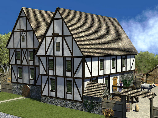
Medieval houses from the 17th century

What are your hobbies, both online an offline? Do you somehow involve SketchUp in these?

SketchUp? :-)

Well, maybe teaching. Not necessarily face-to-face or even online training courses but I create informative materials. Maybe this sounds boring, but how about if I put this way: currently I am dreaming of and working on interactively visualising the historic phases of my city in 3D, starting with the Roman Empire and maybe ending with the late 19th century industrial boom.

Now imagine this provided kids the ability to learn their local heritage online. Nowadays, they are occupied with those strategy or FPS games, but in this case, they could also learn from it. Maybe I am still a child myself and dreaming.

Do you build or have you built any SketchUp Ruby Scripts? / API based add-ons? / Dynamic Components?
Well, my background is history, archaeology, and maybe law (I am also a lawyer), so I have never been a technically oriented person. Whatever I cannot see with my eyes when creating it is not of much interest to me. However, I have built some very simple Dynamic Components. When I model “professionally,” I do archaeological reconstructions. Dynamic Components are not too useful since my models are always unique. Of course, I fully understand its use when it comes to product or construction parts manufacturers and developers.

There are so many talented and generous ruby scripters out there that it would be a waste of resources to start playing with it and keep hindering them in their work with my basic questions. I, more or less, see what's going on in a ruby file and modify it to my needs.

The Google Earth plugin is different; I have ideas about where and how I would like to implement it. I also have some basic knowledge of website development, so lately I have started to play around the Google Earth API (as it is also required for becoming a Google Qualified Geo 3D Developer) as well as studying the kml documentation, but I will never be a real coder.

What plugins do you use? What is your favorite?

You should see my plugins folder. There are 246 items (out of which 44 are sub-folders)! I have to scroll my Plugins menu on my 22” monitor and that's just the Plugins menu – how about the Tools, the Camera, the Draw menu or the Context menu? I even have plugins in my File menu. Which one are you interested in? :-)

Maybe a bit more seriously... Yes, I have lots of plugins but they are for all sorts of different tasks, and sometimes I do not use one for weeks or months. As for a favorite? Well, in light of the above, it would be really hard to say anything.

As an example: when I had to model a bunch of arches, I used thomthom's UV Toolkit a lot to texture them. Then, that was my favorite. When I have to engrave some 3D text into a curved shape, I “bend it like Fullmer”. When I had to adjust the roof to an irregular Roman horreum (granary), I used the sheer function of Fredo6's FredoScale. If I need to render section cuts in an external renderer, I use TIG's SectionCutFace and Whaat's Zorro2 plugins.

But there are so many. This is of course a bit unfair with the rest (240?) of those wonderful plugins and plugin writers who are now left out of my quick list here.
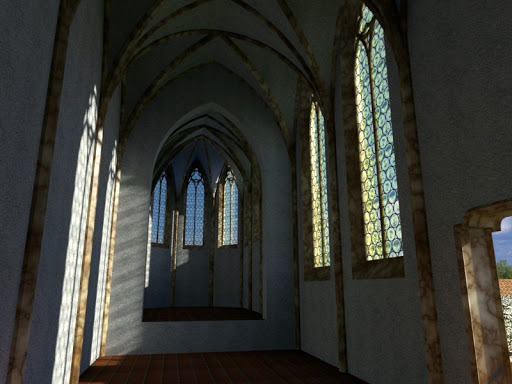
14th century Carmelite church

Do you use any other software alongside SketchUp?

My main modeling platform is SketchUp of course. However, sometimes one cannot avoid using other things as well. There are some organic modeling tools like Sculptris or third party rendering or composing software like Twilight, Thea, Simlab Composer, or the free but excellent Kerkythea and others. I have a couple of tree generating applications (for less poly-sensitive programs of course) like tree(d). There are different applications to convert file formats from/to each other like Meshlab, and of course, I use a bunch of image editors for all kinds of post processing – shader creation, batch processing, video editing or even just for viewing.

Lately, I am getting more and more interested in displaying 3D content on the web. The Google Earth and the Google Earth Plugin would be one way. However “Your World in 3D” does not “represent actual structures” so Google Earth – for the time being – is not the right solution. There are other cool apps like 3dvia or Unity3D that display your 3D world on the Internet.

What communities do you participate in? Are they all specific to or relating to SketchUp?

The two most important ones are the SketchUcation Community Forums (where I am also a forum administrator) and the official Google SketchUp Help Forum (where I am a Top Contributor – or “SketchUp Sage”). I visit these forums every day – or more precisely, whenever I work from home, I am practically online on both in one of my browser tabs.

Then there are some I am subscribed to and lurk around like the 3D Warehouse Forum, the Google Earth Help Forum, or TaffGoch's incredible Geodesic Help Group.

Some other ones I regularly visit and participate in are mainly also related to SketchUp forums of third party applications I use and such. On some I only lurk as a beginner while I am more experienced with other programs and participate more actively myself.
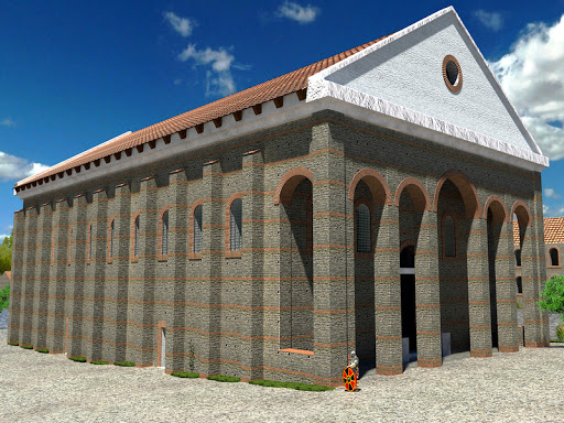
Roman basilica from the 4th century

What is one of the most rewarding experiences you’ve had as a Top Contributor?

I can’t really pick one. It is always rewarding when someone finally understands a tricky thing in SketchUp or when a “newbie” finally has that breakthrough moment and becomes part of the “Anonym SketchUholics' Club”. And of course, being invited to two consecutive 3D BaseCamps, meeting all the SU folks and many users I know from the online communities was something very special that I will always remember.

Why do you participate in the SketchUp community?

Because I am a selfish, avid and lustful person and I want that rewarding feeling above every day. ;-)

More seriously: I don't know. By now, it is also my “job” and daily routine. When I was a newbie, I was far from being able to do what I planned. I learned a lot on the old be @Last Forums. Don't get me wrong; SketchUp has an exceptionally good help documentation and used to have back then as well. But often, beside the “how-to's”, you also want to know the “why's” and all these things can only be picked up in a community. So now it's kind of time to give something back to the same community (where only the members change).

Do you use any other sites?

Well, there are two different things here. Sites that I use for myself – apart from “working” on them of course – mainly good CG texture collections, the 3D Warehouse (although I tend to model almost everything for my own models) and the help forums of other 3rd party applications.

Then there are sites, tutorials, videos (and let's not forget the SketchUp Help Center), etc. that I visit to pick up links for others to better understand what I want to explain. The reference system of the SketchUp Help Forum is extremely useful, so in the course of hanging around there it's more or less sufficient. I would still highlight one that is often overlooked: the SketchUp Sage site, which is an extremely rich collection of everything SketchUp related, maintained by our Top Contributor SketchUp Sage, catamouintain.

Do you have a favorite modeler? A favorite style?

Hm. This is a question just like my favorite plugin or most rewarding experience. But I'll pick one of the many: Aerilius. He does an amazing job with not only modeling and rendering archaeological reconstructions but also with visualizing them both with 3D panoramas and on Google Earth (beside the “representation of the actual structures”) with interactive tours around the reconstructed models. Just two examples: the Roman Villa at the Weilberg – “now” and “then” or the Limburg Monastery (also in the panoramas above) “now” and “then”. Also, he is a “supermodeler” and has the same endeavor as me – that Google Earth will finally incorporate 3D content of no longer existent, archaeological reconstructions. I can hardly wait for him to become a Top Contributor and SketchUp Sage (which he is even without the badge). I guess by the time this interview is released, he will already have become one of us.

A favorite style? If this is about SketchUp Styles, maybe Dave Richards makes the best use of them. As he is a woodworker, he probably makes more use of the sketchy styles than a landscape designer would.
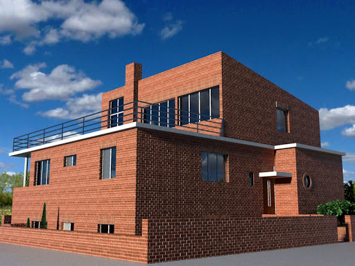
Bauhaus house from the 30's

What is the most fun thing to do in SketchUp?

Modeling. Just doodle around without any particular purpose and try out different things that you may never do otherwise. This is also good for learning, especially for beginners. It is always important not to mess up their “real” models and projects with some experimentation. But then it is also fun when you are doing modeling on a real project. To see the model growing in front of you and to enjoy the real time experience while doing it. This is when you “knead the dough”. Then put it into the oven and see it being baked in a photo-realistic renderer, and you get the yummiest thing in the world!

If you could plant one idea in the mind of any new SketchUp user, what would it be? (This is your chance to educate a user before they start using the forum!)

Practice before you model “live”. Read the documentation and re-read the documentation. What my friend and moderator on the forums has in his signature (if I may): “The average user never reads user guides and tutorials, that's why they are only average”. Go to the forums if you get stuck and ask.

Asking is free and the ones who take their time to constantly be there as helpers, really mean to help. And when you ask, try to be as clear and as specific to your problem as possible but only as far as SketchUp and the modeling part is concerned – do not bring in too much unrelated, special stuff. Also, if possible, provide images, upload your model so that others can figure out what you are talking about even is you are not 100% familiar with the correct terms. But questions like “How to make a car” will most probably never be fully answered. However, the most important thing is to enjoy what you are doing! SketchUp lets you do that so allow it to help you.

See more of Gaieus's beautiful work here.

Posted by Jody Gates, Strategist, Consumer Operations

Cricket Season Has Begun!

Monday, December 6, 2010

[Cross-posted from the LatLong Blog]

Summer has arrived in the southern hemisphere, which in Australia, means cricket!

The Ashes,” a tournament series played between England and Australia, recently began a couple weeks ago so the competition is underway. It’s said to be international cricket's most celebrated rivalry, dating back to 1882.


The series is played biennially, alternating between the United Kingdom and Australia. Since cricket is a summer sport, and the venues are located in opposite hemispheres, the break between series alternates between 18 and 30 months.

In Australia, where the tournament is being played this year, the “grounds” (stadiums) used are "The Gabba" in Brisbane, the Adelaide Oval, the WACA in Perth, the Melbourne Cricket Ground (MCG) and the Sydney Cricket Ground (SCG), in that order.


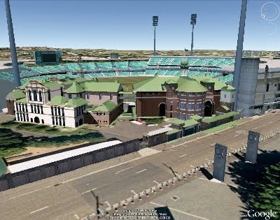
A view of the Sydney Cricket Ground in Google Earth


So whether you’re a cricket newbie like me, or a veteran “cricketer,” we hope that you’ll explore all of these grounds in Google Earth, or just enjoy our video tour, today!


Posted by Bruce Polderman, Product Manager

Ponoko 3D Printing Challenge: Two weeks left

It's Monday -- time for my weekly reminder about entering the Ponoko 3D Printing Challenge before it's too late. You have two more weeks to put together an Instructable about using SketchUp and Ponoko together. Fabulous prizes await you if you win. The future of the digital making revolution is in your hands...

Welcome, Google Apps users!

Friday, December 3, 2010

Google Apps recently launched an improvement that made dozens of Google services available to Google Apps users for the first time. As part of this launch, Google SketchUp and 3D Warehouse are now available to our Google Apps users for free with their Apps accounts.

Google Apps is Google’s suite of cloud-based messaging and collaboration apps, including Gmail, calendar, documents, spreadsheets, and more, specifically optimized for use in organizations. These services, which run entirely in the cloud, are used by over 30 million users in small and large businesses, educational institutions, government agencies, and non-profit organizations around the world. You can learn more about how Google Apps can lower IT costs and improve productivity and collaboration at your organization at google.com/apps.

For those users who have a Google Apps account, if your administrator has already transitioned your organization to the new infrastructure, you can get started using SketchUp and 3D Warehouse at sketchup.google.com with your existing Apps account.

For more details, read the complete post on the Google Enterprise blog and follow all the updates on other newly available services for Google Apps users.

Posted by Gopal Shah, Google SketchUp team

Supermodeler Story: Zeljko Zdravkovic

Thursday, December 2, 2010

Here’s a testimonial from Zeljko Zdravkovic (a.k.a Zex), who told us about his experience geo-modeling his hometown of Belgrade, Serbia.

I started modeling Belgrade because I wanted to create a 3D identity for my city. I first learned that it was possible to add a 3D building to Google Earth several years ago. I was very surprised and curious about this. I had also noticed a number of untextured models in Belgrade, and decided that I wanted to change that.

As is often the case when learning something new, I experienced many false starts. I didn't know how to use SketchUp, or, publish a model to Google Earth. I tried and tried, in failure. It wasn’t until I noticed a little checkbox labeled “Google Earth Ready” that I realized why my models where not appearing! I laugh about it now, but it was very frustrating then!

I started to make 3D models in the summer of 2009. Today you can see over 500 models that I’ve made. When combined with the work of other geo-modelers, there are over 800 models in Belgrade, and almost 1200 models in all of Serbia (including Belgrade).


With the exception of some buildings and monuments, I’ve finishing nearly 90% of the city area. I’m hoping to complete the entire city by the end of 2011 or beginning of 2012.


Unfortunately, Belgrade area is not available in Building Maker today. If it were, it would certainly have been far faster and easier. But when I finish the entire city, Belgrade is going to be one of the most quality-built 3D cities in Google Earth, and that’s something that I take a lot of pride in—for me, model quality is number one!

Црква Светог Марка (St. Mark's Church)

Google Earth is an excellent opportunity to promote your city to other people all over the globe. 3D models can benefit a city a lot. People all over the planet can see, learn from and enjoy the architecture of every building we make.


City TV Studio B now uses 3D “New Belgrade” area in Google Earth for traffic service information on their web site. They use a 3D map in their television broadcast. It’s such a fantastic feeling when you see your 3D models on TV, or used by others for very useful purposes.

It is so amazing how Google Earth has enabled the world to become so personal to us. Now anyone can visit every corner of the globe. It’s really amazing to me!

Ready... set... track Santa!

Wednesday, December 1, 2010

[Cross-posted from the Official Google Blog]

From feasting on a turkey dinner to singing carols around the fire, there are certainly plenty of traditions to enjoy during the holiday season. Much to the delight of the child in each of us, the ritual of gift-giving continues today, and I know I still find cheer at the bottom of my stocking every Christmas morning.

Another tradition that brings joy to youngsters everywhere is the one started in 1955 by NORAD, the North American Aerospace Defense Command, which every year counts down to Christmas Eve and tracks Santa’s whereabouts as he delivers presents across the globe. Google similarly started tracking Santa in 2004 and has been partnering with NORAD on this fun project since 2007. Keeping the tradition alive, today marks the kick-off of this year’s countdown at www.noradsanta.org. On the NORAD website, kids can play holiday-themed games (a new one is released each day) and get updates from the North Pole as Santa prepares for his big sleigh ride.

If you haven’t tracked Santa in years past, we hope this is the year you’ll start a new tradition of visiting www.noradsanta.org and following Santa’s journey all around the world. Starting at 2 a.m. EST on December 24, you’ll be able to track him in real-time on Google Maps from your computer or phone as well as on Google Earth with the plug-in by searching for [santa].

So this year, along with my family’s usual tradition of gathering around to hear my mum read “Twas the night before Christmas,” we’ll gather around the computer to see when Santa might be coming to our neighborhood. In honor of the occasion, I wrote a new opening verse:
'Twas the night before Christmas, and Santa was near
According to NORAD, he would soon be right here
So we hopped into bed and dreamt of new toys
And awoke in the morning to much Christmas joy

Happy holidays to all, and to tide you over till Christmas Eve, enjoy this video with highlights from Santa’s journey last year!