The California Bay Area, now in 3D

Thursday, January 27, 2011

Nearly five years ago, Google embarked on an ambitious project to work with everyday users like you to create a 3D model of every building in the world for Google Earth. We’ve made strides toward our goal adding millions of buildings to the 3D layer of Google Earth in cities across the globe. And today, we’re pleased to announce another big step in that direction with the release of expanded 3D coverage of the California Bay Area (which also happens to be the homebase of Google’s headquarters!). With Google Earth’s “3D Buildings” layer turned on (or by using the Earth View in Google Maps), you are now able to tour tens of thousands of new buildings in the 50-mile stretch between San Francisco and San Jose, as well as select areas of the East Bay, like Oakland and Berkeley. You can now fly through the air and view urban centers of cities like Foster City, Mountain View, Palo Alto, Oakland, Redwood City, Santa Clara, Santa Cruz, San Mateo, and Sunnyvale, in 3D. If you’ve never been to the Bay Area, start by visiting iconic landmarks like the Golden Gate Bridge and the Ferry Building (note: you will need to have the Google Earth plugin installed to view these links). While in San Francisco, you may notice that in addition to 3D buildings, there are also 3D trees throughout the city. This is a new feature we released with Google Earth 6.0, and San Francisco is one of the first few cities to showcase 3D trees.
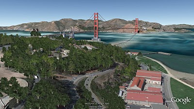
The Golden Gate Bridge and 3D trees

The Bay area peninsula is also the home of Silicon Valley. Several technology companies are available to view in 3D, including of course, the Googleplex in Mountain View.
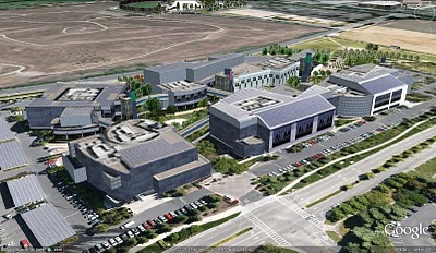
Googleplex in Mountain View, CA

Sports fans might be interested to check out the HP Pavillion, where the San Jose Sharks play, as well as AT&T Park, home of the 2010 worldseries champion, SF Giants. Music lovers may also want to view the Oracle Arena in Oakland and Shoreline Amphitheatre in Mountain View. If you’re starting college soon, take a virtual tour of the Stanford and UC Berkeley campuses.

UC Berkeley Campus

Of course, this is just a small sample of the several thousands of buildings you’ll find in the area. You can check out an expanded tour we created, or you can open up Google Earth and explore for yourself. As you go on your virtual tour, you may notice that several buildings were created by users, who continue to be an integral part of our 3D building efforts. For example, supermodeler, PeterX created nearly 1,000 buildings around the Bay Area, including the NASA Ames Research Center.

PeterX's model of the wind tunnels at the NASA Ames Research Center

If you’d like to get involved in modeling your town (or any other location), we have several free (and easy!) tools to get you started. With Google Building Maker, you can create and contribute a building in as little as 10 minutes. And if you’d like to refine your building, bring it into Google SketchUp for fine-tuning. Everyday, we are working on adding more 3D cities to Google Earth as part of our larger mission to organize the planet’s geographic information and make it accessible to all. Happy touring! Posted by Gopal Shah, Google SketchUp team
A geo-modeling competition in Poznań, Poland

Wednesday, January 26, 2011

Cities are exploring creative ways to get themselves on the virtual map. Some, such as Chula Vista, California are asking local residents to help. Others, like Mishawaka, Indiana and Poznań, Poland are running contests with cash awards to entice modeling support. While the approaches vary, what’s clear is that cities see the value of a digital representation that is publicly available on Google Maps and Google Earth.

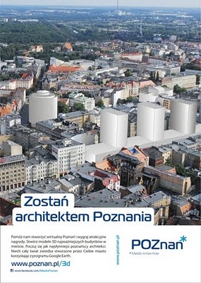
The City of Poznań announced the results for its competition last week. The goal of the organizers (as outlined on the competition web site) was to model specific buildings on the old imperial route through the city. The route contains lots of heritage buildings that the city is eager to promote, including royal palaces, opera houses, the old market area, and other historic buildings.

The competition poster for Poznań's geo-modeling competition

The Poznan competition was uncharacteristically short – November 22 through December 19 – interested parties had to act fast. Word of the competition quickly spread to others in the geo-modeling community. Entrants possessed a range of experience, but (not surprisingly) several experienced geo-modelers participated. These included Marcin Kruk (nevermor) and Supermodelers Filip Michałowski (Athinaios) and Tomasz Szular (tomcioZG).

The city hasn’t indicated how many entries were received, but it recently announced the winners. Entries were received from as far away as the United States. The competition was supported by the local Google office, who provided prizes to the winners in addition to the cash prizes that were awarded by the city.

Church of St. Anthony of Padua (Kościół św. Antoniego z Padwy) by Zuzanna Kurzawa

Local geo-modeler tomcioZG had this to say about the competition: “I'm happy with this contest and glad that someone in Poland is trying to organize something like this. I only wish the duration were longer – I submitted my last model seven minutes before the end of the competition!”

He went on to say: “I know that this competition was to determine interest, and I think City Hall should be pleased with the result. I checked all the models and they are made really well. After the competition I spoke with an employee of Poznań City Hall, who told me that if all goes well, they will hold this year a new contest.”

The city is still in the process of publishing the models to the 3D Warehouse. Some of the results can be found in this collection.

Posted by Bruce Polderman, Product Manager

Photo-rendering with Shaderlight

Thursday, January 20, 2011

If I had a nickel for every time someone asks me which renderer they should use with SketchUp, I’d have a fleet of helicopters perched on the turrets of my castle. One look at SketchUp’s Fan Photos page on Facebook is all you need to understand our community’s obsession with delicious photo-realism. There are piles of fantastic rendering tools to choose from, and more become available all the time. Happily, most of them have a “free mode” that you can use to try things out.


Shaderlight, an awfully-impressive (and relatively new) offering from ArtVPS, is one such rendering tool. Its interface is clean and straighforward, there’s a free version available and the video tutorials are easy to follow and comprehensive. It’s currently only available for Windows, but I’m told that a Mac version is in the works. Here are some tasty sample renderings to whet your appetite:

Boat interior rendering by Sully114


Rendering by Daniel Tal


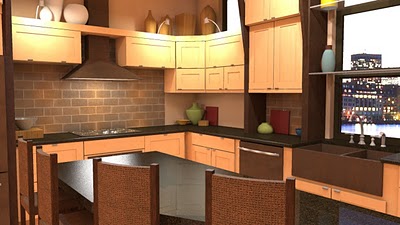
Kitchen rendering by Eric Schimelpfenig


Villa interior rendering by Sully14

In the interest of fairness to all of our rendering friends, our plugins page lists some of the other tools you can investigate if photo-realism is your bag.

Update: The target launch date for Shaderlight for Mac is early March.


The 3D Philippines Initiative

Tuesday, January 18, 2011

We recently made a trip to Manila to help out with the 3D Philippines Initiative started by COMMDAP. The initiative’s goal is to create an entirely 3D Philippines using Google SketchUp and Google Earth so that information can be shared and experienced in a richer way than with just a basic map. It was an action-packed three-day schedule.

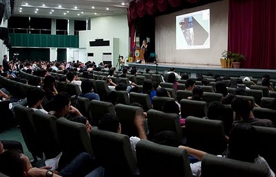
The first event was a general geo-modeling presentation for students and teachers at the University of Makati, which was part of the school’s “Technology Week”. The second event was a presentation to the Google Technology Users Group of the Philippines on geo-modeling and becoming a Geo 3D developer.

Me (Nicole) onstage presenting the basics of geo-modeling

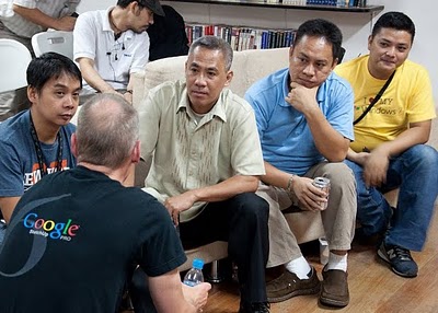
Bruce Polderman answering questions about certification for Geo 3D developers

Next, we held two full-day workshops at the university: one for educators and trainers and one for students. These workshops focused on developing basic modeling skills by means of an introduction to SketchUp, but we taught aspects of photography, photo editing, and other techniques specific to geo-modeling as well.

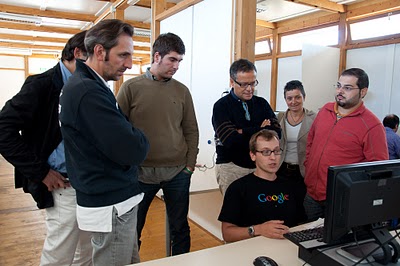
Teachers' workshop at the University of Makati

Group photo with the teachers

Students' workshop at the University of Makati

Group photo with the students

Concurrently, COMDDAP was hosting the Manila Expo 2010. There, they had a designated area where visitors could learn about Google Earth and explore the virtual globe both on a standard computer AND on a super-cool interactive touch-sensitive projection white board.

Now THAT'S a touch screen!

Take a look at this photo album for more pictures of our visit to the Philippines.

Help rebuild L’Aquila

Monday, January 17, 2011

The city of L’Aquila, Italy was turned to rubble by a powerful earthquake in April of 2009. As is the case with many natural disasters, public attention has steadily declined since the earthquake. A year and a half later, little progress has been made to rebuild this ancient city.

So we decided to offer help in the best way we know how: with technology.

As we outlined in this post, employees from the Google SketchUp team offered to assist in the effort. Workshops were held to collect photographs and train local volunteers in the use of SketchUp as a geo-modeling tool.

While this was happening, we were collecting aerial imagery that would enable us to make L’Aquila available to geo-modelers around the world in Google Building Maker.

With L’Aquila now available in Building Maker, we’ve organized a follow-up workshop where Google staff will return to work with volunteers to model the city. The workshop is scheduled for January 22-23 at the University of L’Aquila. Seating is limited. Register here if you would like to attend.

Of course, not everyone who may be interested in volunteering can attend, so we’d like to invite geo-modelers around the world to join us virtually. In addition to supporting a good cause, geo-modelers who join the effort will be awarded a special badge in the Google 3D Warehouse.

Visit the L’Aquila 3D website to learn more about the project.

To get started, follow these simple steps:

  • Watch these helpful getting started videos
  • Launch Building Maker
  • Select “L’Aquila” from the list of available cities
  • Zoom into the city and find a building of interest. Tip: be sure to avoid buildings that are currently being modeled by others by looking for blue dots.
  • When you’ve finished your model, publish it to the 3D Warehouse. If it passes our review, it will appear in the 3D Buildings layer of Google Earth within a week or two, depending on the volume of models.
Thanks for your support!

Posted by Bruce Polderman, Product Manager

Rebuilding L’Aquila in 3D with Google SketchUp

Thursday, January 13, 2011

On April 6, 2009, a powerful earthquake struck l’Aquila, Italy. Three hundred and eight people died, and most of the buildings in the city center and surrounding areas were damaged or destroyed. About six months ago, we received an email from a British architect named Barnaby Gunning proposing an ambitious project: to use Google SketchUp to build a digital 3D model of the city, as it is now, in order to stimulate discussion about its reconstruction. He had already created a website—called Comefacciamo ("What can we do?")—to contact and organize volunteers.


Barnaby Gunning with the project T-shirt

Barnaby asked if Google would support a geo-modeling workshop in L’Aquila in an effort to create a digital model of the city. An engineer working on SketchUp and an Italian by birth, I was asked to travel to L’Aquila and give geo-modeling classes in Italian. I was excited! I could visit my motherland, teach people about the product I work on and help out with a project that could have a great impact on reviving the city. I ended up teaching six full-day classes over the course of two trips in October and November.

Teaching Google SketchUp skills to volunteers in L’Aquila

Teaching in Italian about a product on which I work almost exclusively in English proved to be more challenging than I thought. It took me awhile to get used to using the correct Italian name for the Push/Pull tool: Spingi-Tira. (It’s more fun to say, though.) The passionate volunteers who attended my classes more than made up for the language frustrations. Not only were they interested and attentive learners, but their desire to do something for their beloved city was contagious.


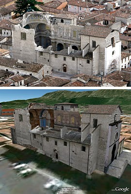
The church Santa Maria Paganica in real life (top) and modeled with SketchUp in Google Earth (below).

The modeling phase of the project is now in full swing. Several of the volunteers’ models have already been accepted into Google Earth—you can see them in your browser if you like. You can even take part in the project by helping to model the city from wherever you live. We’ve added L’Aquila to the list of places where you can use Google Building Maker to create geo-models, so no previous 3D modeling experience is necessary. If you’d like to dive in a little deeper, you can use SketchUp in connection with the many photos and other information on Barnaby’s website.

My few days in l’Aquila teaching SketchUp proved to be a fantastic experience. I met so many people who are enthusiastic about this project and willing to sacrifice their weekends to learn how to model, and to provide an exhaustive photographic record of the current situation. The time I spent with them was a wonderful remainder of the love they feel for their city—a love that I now share. I count myself lucky to be a participant in this important project.

Posted by Simone Nicolò, SketchUp Software Engineer

We fixed the shadow bug!

Wednesday, January 12, 2011

Earlier today, we announced a maintenance release for Google SketchUp 8 (free and Pro) that is a free upgrade for all SketchUp 8 users. One of the bugs we’ve fixed is the oldest and thorniest in our bug tracker. Most folks call it the “Shadow Bug.”

Let’s roll back the clock a little bit before I explain the fix. In the spring of 2001, we introduced real-time volumetric shadow rendering in SketchUp 1.1. At the time, only video games were really doing this sort of rendering, and it was pretty exciting to see shadows cast from a model that you made yourself. When I got my first demo, I declared them to be the most “Undeniably Sexy” thing that I had seen all week. It was shortly after that that I left my day job to join @Last Software – SketchUp was clearly something that I had to be a part of.

Awesome though shadows were in most cases, there was a fatal flaw. When the camera passed inside a shadow volume, there were places where the rendering algorithm just plain fell flat on its face – leading to flashy, jagged and just plain wrong-looking shadows from some points of view. Unfortunately, there wasn’t any obvious way around that problem.

In the SketchUp 3 and 4 release cycles (launched in July of 2004), we worked on this problem some more and found a new algorithm that looked promising. Unfortunately, we found that this algorithm, while usually better when the camera was inside the shadow volume, failed even more spectacularly than our original algorithm in other common uses. Admitting temporary defeat, we pulled the new algorithm out and went back to the drawing board again.

Hero engineer sporting early @Last Software t-shirt

As I’ve often said when asked about “the shadow bug”, the only way we’d be able to fix it is if we came up with a clever new algorithm. As luck will have it, one of our engineers (the same guy who implemented the original shadow rendering ten years ago) never quite gave up on the problem. And a few weeks ago, he figured out a new solution. Just like that. I’m proud to say we’ve (finally) fixed shadow rendering for all those cases where the camera was inside the shadow volume and included it as a part of today’s maintenance release. Need a visual? Here’s a video that shows the our new and improved shadow rendering at work:


There’s lots of other good bug fixes in M1, and it is both free and recommended for all users. Here's how to make sure you have the latest version of SketchUp 8:

Windows: Choose Help > Check for Update
Mac: Choose SketchUp > Check Web for Update

Posted by John Bacus, SketchUp Product Manager

An important update for SketchUp 8

Sometimes a haiku says it best:

new SketchUp version
shadows work much better now
farewell artifacts!


You'll want to download today's free update for SketchUp 8 as soon as possible. It contains (among a great many other things) fixes for for raster image export at high resolutions on Windows, and for the dreaded Shadow Bug. If you listen carefully, you can hear the sound of millions of modelers uncorking Champagne to celebrate. Believe me – we're thrilled, too.

Here's an overly-dramatic video that shows the Shadow Bug fix in living color.

The newest version of SketchUp 8 (free and Pro) is available today in English, French, German, Spanish, Italian, Korean, Japanese, Traditional Chinese and Brazilian Portuguese. Stay tuned for Russian, Dutch and Simplified Chinese; they’re coming soon.

Here's how to get the latest version of SketchUp 8:

Windows: Choose Help > Check for Update

Mac: Choose SketchUp > Check Web for Update

Please feel free to express your own euphoria in the form of a haiku in this post's comments thread.

Udpate: Added Korean to the list of available languages.


SketchUp Pro Training Schedule: Jan/Feb 2011

Tuesday, January 11, 2011

Our January and February 2011 SketchUp Authorized Training Center schedule is now available. The map below contains information on specific locations, dates, and courses provided:


View in a larger map

High school mashup: Digital History Class

We’ve long been admirers of the creative things educators and students do with SketchUp. Michael Hathorn is a high school teacher in Hartford, Vermont who teaches an innovative class that he describes as a “digital history” of their small town. They document White River Junction’s history by constructing 3D models of the town’s buildings and geo-locating them in Google Earth.

We’ve blogged about Hartford High before – and even found his work as an educator deserving of an official case-study video. Mike and five of his students presented at our Google Geo Teacher Institute last summer; since then, all of those students have gone off to college with a serious tool set of skills learned in Mike’s class.


This year, high school senior Michael Bateman created a video about his teacher’s class (above). In it, he and others explain why their project is so valuable in relation to typical high school classroom coursework.

There’s no doubt that engaging students can be difficult; it’s fun to see why Michael and his peers are so jazzed about this class. I’m also envious of his mad videography skills. Nice work, Mike and Michael.

Augmented Reality for SketchUp

Friday, January 7, 2011

The first time I saw Augmented Reality in action, I wondered if I'd accidentally fallen through a wormhole on the way to work; it's the kind of thing you'd expect to see on Boba Fett’s BlackBerry. AR is downright futuristic.

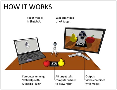
In the 3D modeling sense, AR involves combining a live video stream with a 3D model to create the illusion that the model is a physical object in the real world. All you need is a webcam (the ones that are built in to many laptops work just fine), a 3D model (SketchUp takes care of that), a printed-out paper "target" and a piece of AR software that can put everything together. This video shows AR in action:


And here’s an illustration that shows the setup:

A simple Augmented Reality setup for SketchUp, using an external monitor to show the video output. Note that a second monitor isn't necessary for using this plugin.

Thanks to an Italian outfit called Inglobe Technologies, SketchUp users have been able to ride the AR wave for a while now. They've just released version 2 of their AR-media Plugin for Google SketchUp. Three great things about this shiny, happy piece of tech:

  • It's available for both Windows and Mac OSX.
  • It's available in three flavors: Free (Personal Learning Edition), Professional Lite and Professional.
  • I was able to use it, which means that it can't be that hard to figure out.

Start out by grabbing the Quick Start Guide; you'll find the relevant links about halfway down the plugin's webpage. Follow Steps 2 and 3 to download and install the software; the free Personal Learning Edition will let you see how everything works without spending any money. After that, achieve instant gratification (my favorite kind) by skipping ahead to Step 6 in the Quick Start Guide: "Creating your first Augmented Reality Scene".

Here’s a video that shows off the new features in ARmedia Plugin 2.0:


Please use this post's Comments thread to discuss the ways you think AR might benefit you.

The coolest (coldest?) model around

Wednesday, January 5, 2011

Tobi Merk is a Supermodeler from Germany whose models of Nördlingen
A stunning rendition, Herr Merk.